 LinceCAD
How to import the Spanish cadastral map and the PNOA orthophoto into a DWG (step by step)
This guide covers public data from Spain: the Dirección General del Catastro (Spanish Cadastre) and the Instituto Geográfico Nacional (IGN) only cover Spanish territory. For other countries, see the limits section at the end. The screenshots show the Spanish interface; commands and labels are given as they appear in the English version of the program.
Many projects in Spain start the same way: you need the cadastral parcel, the buildings on it and an orthophoto
underneath, all in real coordinates. The data is public and free, but putting it together usually takes several
steps: download the parcel, convert it, find the orthophoto, georeference it and place it. In LinceCAD it is done
from a single dialog box with the IMPORTMAP command, and the result stays in the DWG.
Which data is public and where it comes from
- Cadastral mapping, from the Dirección General del Catastro: parcels, buildings and cadastral reference through its INSPIRE service (WFS), and the cadastral plan and sub-parcels as an image through its WMS service. It is unprotected mapping and data: it does not include owners or values. It is free and can be reused citing the source.
- PNOA orthophoto (Spain's National Aerial Orthophotography Plan) and base map, from the Instituto Geográfico Nacional (IGN), under the CC BY 4.0 license: free use citing “© Instituto Geográfico Nacional” (scne.es). The municipality search uses CartoCiudad, also from the IGN.
- OpenStreetMap, as an alternative base map, for occasional use only, as its usage policy asks.
You do not need a digital certificate or an account with any service. LinceCAD labels the source of each image
next to it and puts the source of the vector data on the MAPA-FUENTE layer. Cite the sources on the
drawings you deliver as well.
Before you start: the coordinate system
The data arrives in real coordinates, so the drawing needs a coordinate system. On the Spanish mainland and the Balearic Islands, ETRS89 / UTM is used in the zone of the area:
- zone 29 (
EPSG:25829), west of the 6° W meridian; - zone 30 (
EPSG:25830), between 6° W and Greenwich; - zone 31 (
EPSG:25831), east of Greenwich, including the Balearic Islands.
For the Canary Islands, WGS 84 / UTM 28N (EPSG:32628) is proposed. If the drawing has no coordinate
system, IMPORTMAP sets the one for the area, or the one you choose. To use the current view or a window
as the area, the drawing must already have one: assign it with GEOGRAPHICLOCATION. The Cadastre serves
the data in ETRS89 and LinceCAD reprojects it to the drawing's system.
Step by step with IMPORTMAP
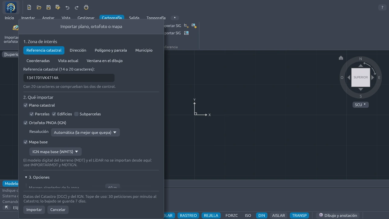
- Type
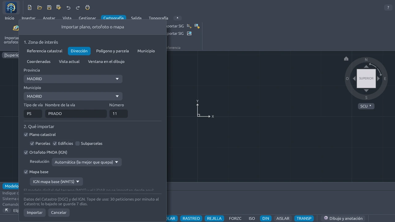
IMPORTMAP, or click Import plan, orthophoto or map on the Mapping tab of the ribbon. - In 1. Area of interest, choose how to give the area:
- Cadastral reference: the 14 characters of the parcel or the 20 of the property (with 20, the two check characters are verified).
- Address: province, municipality, street type and name, and number. If there are several parcels at that address, the dialog lists them so you can pick one.
- Polygon and parcel, for rural land.
- Municipality, with the CartoCiudad search.
- Coordinates, geographic (WGS84) or in the drawing.
- Current view or Window in the drawing (two corners).
- In 2. What to import, tick the Cadastral plan (parcels, buildings and, if you want them, sub-parcels), the PNOA orthophoto (IGN) with its resolution (automatic, 10, 25 or 50 cm, or 1 m) and the Base map (IGN in WMTS or WMS, MTN raster or OpenStreetMap).
- In 3. Options you set the margin around the area, the maximum size of the area and of each image, the transparency of the cadastral plan, whether parcels arrive as entities or as a map layer, and whether the cadastral reference is labeled.
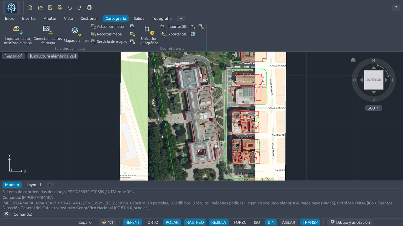
- Click Import. Parcels and buildings are downloaded in the background in 200 m tiles, with a
progress bar and a Cancel button; the images arrive by themselves, underneath the drawing.
Everything is undone in one step with
UNDO.
When it finishes, the command line sums up the area and its size, the coordinate system, what was drawn (parcels, buildings and labels), the images requested and the sources.
Which layer each item goes on
| Layer | Content |
|---|---|
CATASTRO-PARCELA | Parcels, as closed polylines. |
CATASTRO-EDIFICIO | Buildings, with their courtyards. |
CATASTRO-TEXTO | Cadastral reference of each parcel. |
MAPA-BASE | Base map (image). |
MAPA-ORTOFOTO | PNOA orthophoto (image). |
MAPA-CATASTRO | Cadastral plan as a WMS image: sub-parcels, or the parcels if requested as a map layer. |
MAPA-FUENTE | Source of the vector data. |
The layer names are the same in both languages of the program. The images are stacked in that order (base map, orthophoto and cadastral plan) and stay below the entities. Parcels and buildings are ordinary DWG polylines: you can measure, offset and dimension them like any other.
The images are live layers
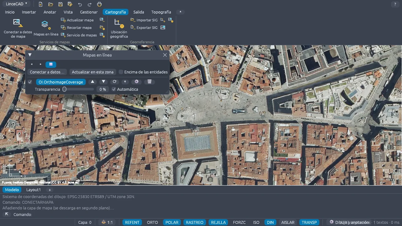
The orthophoto and the base map are online maps: georeferenced images that are requested again
by themselves for the visible area when you pan or zoom. In the ONLINEMAPS manager you turn them on and
off, change their transparency and order, put them above or below the entities, refresh them in the visible area
and clip them (MAPCLIP). With MAPCONNECT you add other WMS, WMTS or WFS services.
Just the parcel: CADASTREDOWNLOAD
If you only need one parcel and its buildings, without images, use CADASTREDOWNLOAD (or
CADASTRE). The dialog box has three tabs: Urban, by address, Cadastral
reference and Rural, by parcel (polygon and parcel). Tick Also draw the
buildings if you want them and click Download. The parcel goes on
CATASTRO-PARCELA, the buildings on CATASTRO-EDIFICIO and the reference on
CATASTRO-TEXTO. The drawing needs a coordinate system: assign it first with
GEOGRAPHICLOCATION.
Limits worth knowing
- LinceCAD makes at most 30 requests per minute to the Cadastre (if it reaches that, it waits) and keeps what it downloads for 7 days.
- The area is cropped to the maximum size (1000 m per side by default) and each image to its pixel limit.
- If a tile does not answer, you are warned and what arrived is drawn: repeat the command to complete it.
- Cadastral mapping has the accuracy of the scale at which each area was captured: it does not replace a land survey.
- The Cadastre and the PNOA only cover Spain. For other countries, add each country's WMS, WMTS or WFS services
(cadastre, mapping agency or national spatial data infrastructure) with
MAPCONNECT; maps are framed by default on the user's country. - The digital terrain model and LiDAR are not imported from here: use
IMPORTDEMandIGNDEMfor that.
Frequently asked questions
Can I deliver the drawing with the orthophoto? Yes, citing the source: “© Instituto Geográfico Nacional” for the PNOA and the base map, and “Dirección General del Catastro” for the cadastral mapping.
Does it work on Linux? Yes, the same as on Windows. Read how to open and edit DWG files on Linux.
What if the drawing I have is a PDF? Read how to convert a PDF to DWG.
LinceCAD brings the Spanish Cadastre and IGN mapping into the program, with a perpetual license. Download · See pricing · Mapping and all other features.